• High Peaks • Wild Peaks • Spirituality
The High Peaks
 The grandeur of the sierra is reflected in the well known phrase “You have a heart hotter than the Sierra Elvira and bigger than the Sierra Nevada” – quite a compliment! The Sierra Nevada National Park besides being the highest in Spain, is also the largest in area, over half of which contains the highest peaks.
Beginning at the eastern end of the range where the peaks are lowest we can prepare ourselves for the higher summits at the western end that reach over 3,000 mts.Travelling the range from east to west we cross more than 100 Kms.
Read more..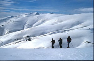 From this string of peaks (which also includes ‘Tajo de la Cruz’ and el ‘Cerro de Almirez’) long ridges and steep sided valleys descend southwards to the river Andarax valley, and to the north sheer sloped escarpments and vertical cliffs tower above the villages of ‘Las Tres Villas’.
‘El Cerro del Almirez’ (2,517 mts) is a mountain shaped like a truncated pyramid. Its summit is truly the best vantage point in all the Sierra Nevada – an ocean of criss crossing ridges definine the massif; to the north with a carpet of maples, and southwards a shimmering sea of alders.
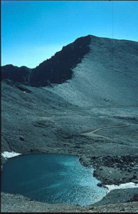
In the pass, in a deep depression on the lower westerly flank of the mountain, there is a lake ‘Laguna Seca’ which dries up in summer. Its just one of the 42 lakes that are found in the Sierra.
‘El Chullo’, the highest peak in Almeria Province, soars above the Marquesado plain which is dominated by the impressive turrets of the ‘Castillo de la Calahorra’ silhouetted against the wide skies of the Guadix plain. Hidden inside this medieval fortress, like a precious stone inside a lump of rock, are the remains of a Renaissance palace with Italian balustrades and fascias of Carrera marble. Another remarkable feature of the plain is the enormous crater of some 1,500 mts in diameter formed as a result of mining for iron ore. The deposits in the Alquife have been worked since Roman times.
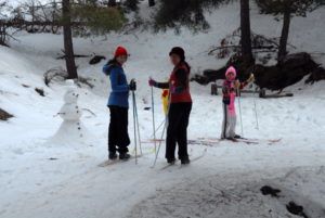
Descending the flanks of ‘el Chullo’ we come to the major north/south crossing point in the centre of the Sierra, the pass of the ‘Puerto de la Ragua’ (2,00 mts). Here there is a cross country ski station and recreation area which is very, very popular with visitors in the winter months, especially Sundays – which might be best avoided if you don’t like crowds of people.
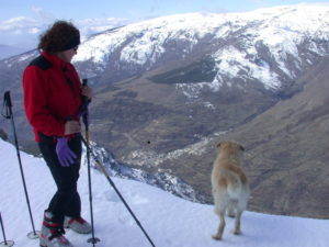
 The passes of ‘el del Lobo’ (2,412 mts), ‘el Collado del Puerto’ (2,621 mts), ‘el de Jerez’ 2,873 mts) and ‘el de Trevelez’ (2,798 mts) are also natural (although not drivable) access routes from the southern Alpujarra to the northern Marquesado. After the Spanish Civil War these mountain routes were often used by black marketeers trading in contraband or forbidden goods. The outstanding peak overlooking these passes is ‘San Juan’ (2,788 mts) whose slopes are a cross country skier’s paradise with no danger of hidden crevasses or sudden avalanches.
Continuing westwards we ascend to 3,000 mts with el ‘Picon de Jerez’ to the north and the altiplano of the Marquesado of Guadix and the finca ‘del Camarate’ where domestic bulls roam free. Nearby is the ‘Lavadero de la Reina’, and at the foot of the ‘Puntal de Vacares’ (3,129 mts) is the ‘Laguna de Vacares’, reputedly the deepest lake in the mountains. In ancient times condemned prisoners from Granada were force marched through the pass on their way to the slave ships awaiting them in the port of Almeria. They had to climb up along the ridge of ‘Calvario’ and up the hill that even today is named after ‘los Presidiaros’, the Convicts.
Although the third hightest mountain in the range, Alcazaba is the least accessible, as its name, the Fortress, suggests. The glacier between Alcazabar and Mulhacen is very impressive and its crossing is known as ‘La Cañada de las Siete Lagunas’, the Glen of the Seven Lakes.
 In the XIX century the botanist Simon de Rojas Clemente, in order to measure the height of Mulhacen, had to descend from the summit recording levels all the way to the coast at Castel de Ferro by way of the Contraviesa range; at the same time he made a study of all the plants he encountered en route. The military used a different system; even today one can still see the remains of their refuge where military personnel stayed on the mountain top for more than a month waiting for the right weather conditions and clarity that would enable them to see the light signals emitted from the Algerian mountains across the Mediterranean Sea (M’ Sabilia and Filhaussen) and from the ‘Tetica de Bacares’ to the north east of the Sierra de Filabres on the mainland. Nowadays, after years of preparation, there is a geodesic link up between Spain and North Africa making it possible to triangulate correctly maps in both continents.
After some twenty years the intention of the Ministry of of Defence is still on record as wanting to install a radar station on the summit of Mulhacen. At the time there was a mass demonstration in protest on the streets of Granada the likes of which have not been seen in modern times. It effectively paralysed the military’s efforts and saved for posterity the sacred summit and final resting place of the last Moorish king of Granada. The well known medic and mountaineer Lorenzo Arribas was prominent in the campaign, as well as working at the same time to preserve the peaks above Pampaneira from despoilation and creating a mountain refuge 500 mts below the peak.
On the flanks of Mulhacen there is one of the largest lagoons in the Sierra,’ La Laguna de la Caldera’. The Swiss Andalucian Diego Martin wrote in 1894 that it was popularly believed to be bewitched, and that it was linked directly to the sea through a hidden channel under the mountains. It was said that strange songs emanated from its centre, and when the winds blew its surface into waves their splashing and pluming crests sounded like souls in pain. One thing is for sure, it is the first lake to be polluted due to its proximity to the ‘highest road in Europe’, as it presumes to be known. Fortunately, although perhaps a little too little and too late the ‘Delegacion de Medio Ambiente’ (Environment) has recently closed the road to public traffic.
 On the north face of Mulhacen the river Genil, which flows through the centre of Granada, rises from the ‘Laguna de la Mosca’. These great peaks of more than 3,000 mts separate the northern gradient, the Altlantic face (hydrographically speaking), from the southern gradient or Mediterranean face.
On the next summit, ‘Veleta’ the second highest peak in the Sierra Nevada at 3,327 mts, there is a corral that is so exposed to the elements that even the most experienced mountain man cannot help but feel ‘vertigo’ on looking out. Here on the north east face is the Sierra Nevada ski station whose 50 kms of pistes obscure the ravages of earth moving and dramatic changes of direction of the original natural watercourses that were necessary to adapt the terrain and provide snow cannons, necessary for international level competitions.
The final peak is ‘El Caballo’ at 3,013 mts, which curiously is the mean height of all the peaks. From here we descend into the valley of the river Monachil passing as we go down the impressive pointed spires of the ‘Alayos de Dilar’, the pyramid of ‘Trevenque’, and the vertical rock faces of the ‘Tajos de Cahorros’ looming above the river.
Over the wild peaks
 From the fertile plain of Granada one sees rearing in up in the distance the great bastion of the Sierra Nevada mountain range with its snow covered peaks. One would never imagine the treasures that lie up there in the seemingly bare rocks – a remarkable cache of nature’s diversity.
If the Donana National Park is best known for its fauna, the Sierra Nevada, the other Andalucian National Park, is outstanding for its vegetation; particularly its wild flowers, with fifty varieties unique to these mountains. This is due to the contrast between the close proximity of the Mediterranean and the great height of the mountains which create an exceptionally wide variation in climate at different altitudes and aspects. For this reason, as well as for its extensive range of wildlife and geographical features, the area was declared a Reserva de la Biosfera by UNESCO in 1986, and three years later a Natural Park on 17 December 1988, with the upper half of the territory being declared a National Park (the 12th in Spain) which enjoys maximum protection.
Read more...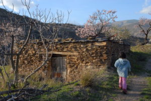
Notwithstanding such international accolades, the Sierra Nevada has been acclaimed for centuries. The poet Zorilla arriving for the first time declared the mountains, “steeped in history and legend, where the African sun caresses the snows”. Washington Irving speaks lyrically of the ” fresh vegetation and temperate airs of a northern climate allied to the ardour of a tropical sun and the clear blue skies of noon” in his ‘Tales of the Alhambra’.
Irving writes fluently of the exceptional quality of the light; the winter clarity, the yellow hues of spring (June) when the high meadows are covered with an intensity of flowering shrubs. Many visitors to the Sierra used to spend the night there specifically to enjoy the sights and scents of the flowers and experience the majesty of the sunsets, and the spiritually uplifting dawns when the first rays of the sun shine on the jagged peaks of the summits. It is from these sunrises that in ancient times the mountains were known as the Sun Mountains – for the Romans ‘Mons Solarius’ and for the Arabs ‘Sulayr’. They were also called, as they are today, Snow Mountains, Yabal al Taly.
Sun and snow have defined these mountains throughout their history: As it is expressed in the popular song by Henrique de Jorquera in the 17th century:
“There are three things in Granada that last throughout the year: Snow in the Sierra Nevada, rosy sunburn on the face, and mud slush in the calle Elvira”.
 The sun shines more than 250 days a year, which means that little snow remains in the summer months except in the most hidden corners of the north face. And we musn’t forget that although we are speaking geographically of a glacial landscape, these ‘Snowy’ mountains are just a few miles away from the African continent.
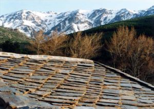
Before the advent of fridges muleeters went up into the sierra to collect snow and ice for domestic and commercial use in the city below. Every night strings of pack animals crowded the mountain highways laden with their valuable cargo. The main route, known as the ‘Camino de los Neveros’, still exists: leading upwards from the city it passes through ‘la Fuente de los Neveros’, ‘el Purche’, the flanks of ‘Domajo’, to the foothills of Veleta (the second highest peak on the peninsula). The city council has now designated this route a Camino Real (ancient right of way) thanks to a local and provincial campaign dedicated to conserving the ancient highways and bridleways. Local town councils let out to tender grazing rights in pastures under their jurisdiction. Sometimes the right to collect snow and ice are passed on from father to son, or are put out to public auction. One of the families that inherited such rights took the newly opened ski station to court in an attempt to get compensation for their loss of income.
 One of the old customs that is being lost when the ice melts is ‘los careos’. This refers to a method of taking advantage of the snow melt that runs down into the rivers and is absorbed during its course into the aquifers and irrigation channels (acequias). These acequias transport and distribute the water, not only for irrigating the crops but also putting it back into the soil to maintain the numerous springs dotting the mountain sides, even at the height of summer when water is scarce. Sadly, what is happening now is that villages heavily dependent upon tourism, such as those in the Poqueira gorge, have practicually abandoned their agriculture and the concurrent irrigation practices: this results in dry unusuable land with a seriously increased risk of forest fire. So now those high mountain villages that used to have so much water they didn’t have need of water meters now find themselves having to restrict water use in the summer months!
The comparison and contrast between agriculture and tourism in villages such as Trevelez, for example, is best seen from the point of view of the young people – who are in no doubt about the economic advantages of the latter.
Spirituality
 Forty years ago the Swiss writer and traveller Christian Spahni wrote that ” the Alpujarra is where man finds his reasons for living”. But these reasons don’t last forever. Agriculture is in decline; hardly anyone looks after the erstwhile large flocks of sheep and goats, mining is no more, phylloxera destroyed many of the vines. As a result the indigenous population is decreasing annually. For those that have stayed it is tourism that, in the main, drives the economy of today.
Recently ‘hippies’ have come to the Alpujarra – although the majority do not stay long: farm and field work are hard and it’s not always easy to integrate socially. More successfully, other newcomers have started small businesses; handicrafts, antique shops, bars and restaurants.
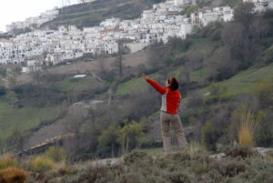
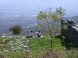
What has lasted, however, is the Sierra Nevada as a place of reflection and meditation. Its beauty is unchanged, indeed there are places that remind travellers of the Himalayas – steep sided glacial valleys, high pastures, high terraces cut into the hillsides, stone built, flat roofed dwellings – it could be Nepal. Up in the southern heights of the sierra at some 1,500 mts there are a number of centres specialising in personal development and spiritual retreats.
The Lama Yeshe founded the first Tibetan Buddist centre in Spain, between Soportujar and Pampaneira.The Dalai Lama made a visit in 1982 and officially named the centre ‘O Sel Sing’, which means Place of Clear Light.
 The Chinese priest ‘Father Peter’ created the Tai Chi centre in the Cortijo de Cortes in the hills above Mecina Bombaron. From Berchules you can see the buildings and the old threshing floor where they used to do exercises on the hillside opposite the village.
After many years giving courses all over Spain, the Japanese Buddist monk Hogen Yamahata chose the Alpujarra to make his home and found his mediatation centre, JIKO AN. The centre is an hour and half’s walk from the village of Yegen.
Lower down, on the valley floor is the agricultural tourist centre Alqueria de Morayma. The owner welcomes teachers and participants in courses of personal and spiritual development to use the specially constructed hall and gardens, and to take advantage of the outstanding views, pure air and tremendous energy of the mountains.
 The Sierra Nevada has traditionally been a place to ‘find oneself’, where ‘time stands still’ for reflexion, relaxation and contemplation. Fidel Fernandez, one of the first mountaineers to climb the Spanish peaks, wrote in 1931 in his book ‘Sierra Nevada’, ” here one finds a miraculous balm that heals the wounds of the soul that one thought incurable”.